
The 2026 hurricane season has taken two very different paths in the Atlantic and Pacific oceans. While the Atlantic has seen below-normal activity, the eastern Pacific has been much busier, with numerous hurricanes and major hurricanes developing over the past several months.
The difference highlights how large-scale weather patterns can influence tropical cyclone development across ocean basins. With the Atlantic hurricane season running through November 30, conditions can still change. Here’s a look at the 2026 hurricane season so far, how it compares with NOAA’s forecasts, and the weather patterns behind this year’s contrasting activity.
The 2026 Hurricane Season So Far
The Atlantic and eastern Pacific entered the season with different outlooks from the National Oceanic and Atmospheric Administration (NOAA). Those forecasts anticipated below-normal Atlantic activity and above-normal activity in the eastern Pacific.
So far, observations largely reflect that contrast.
Atlantic Hurricane Season: Below-Normal Activity
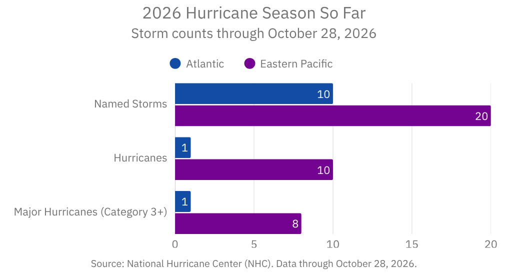
As of October 28, the Atlantic basin had recorded 10 named storms, including one hurricane and one major hurricane. That is well below the long-term average for this point in the season.
The season’s first hurricane, Isaias, developed in October and strengthened into a Category 3 major hurricane, reaching maximum sustained winds of approximately 120 mph. It developed after several months of tropical activity without an Atlantic hurricane.
NOAA’s initial May outlook called for 8 to 14 named storms, including 3 to 6 hurricanes and 1 to 3 major hurricanes. In August, forecasters lowered the expected range to 7 to 13 named storms, including 2 to 6 hurricanes and 0 to 2 major hurricanes.
The updated outlook reflected the atmospheric conditions expected to influence the remainder of the season.
Although the Atlantic has been quieter than usual, a below-normal season does not mean the risk has disappeared. A single hurricane can still produce dangerous winds, storm surge, flooding, and widespread power outages.
Source: NOAA’s 2026 Atlantic Hurricane Season Outlook and August outlook update.
Eastern Pacific Hurricane Season: Above-Normal Activity
The eastern Pacific has experienced a much more active season.
As of October 28, the basin had recorded 20 named storms, including 10 hurricanes and 8 major hurricanes. Accumulated cyclone energy, a measure that accounts for tropical cyclones’ intensity and duration, was about 132% above its 1991–2020 average.
NOAA’s seasonal outlook anticipated this elevated activity. Its forecast called for 15 to 22 named storms, including 9 to 14 hurricanes and 5 to 9 major hurricanes.
The eastern Pacific’s storm count and intensity demonstrate how favorable oceanic and atmospheric conditions can support repeated tropical cyclone development.
Source: National Hurricane Center’s 2026 Eastern Pacific summary and NOAA’s Pacific hurricane outlook.
Why Has the Atlantic Hurricane Season Been So Quiet?
Several atmospheric conditions have made hurricane development more difficult in the Atlantic this year:
- Strong El Niño: El Niño has influenced global atmospheric circulation, creating less favorable conditions for Atlantic hurricanes.
- Increased Vertical Wind Shear: Strong changes in wind speed and direction with altitude can disrupt developing storms, preventing thunderstorms from organizing and strengthening.
- Dry Air and Saharan Dust: Dry air and dust moving across the tropical Atlantic can limit thunderstorm development and make it harder for storms to intensify.
- Greater Atmospheric Stability: A more stable atmosphere can suppress the deep thunderstorms needed for tropical cyclone development.
Together, these conditions help explain why the Atlantic has produced fewer hurricanes than expected so far. However, the season isn’t over, and conditions can still change.
Why Has the Pacific Hurricane Season Been So Active?
Conditions in the eastern Pacific have been more favorable for tropical cyclone development. Several factors have contributed to the basin’s active season:
- Warm Ocean Waters: Warm sea surface temperatures provide energy for tropical cyclone development and can support storm intensification.
- Favorable Atmospheric Conditions: El Niño can reduce vertical wind shear in parts of the Pacific, allowing storms to organize and strengthen more easily.
- Supportive Weather Patterns: Atmospheric circulation across the Pacific has helped create conditions conducive to tropical cyclone development.
- Rapid Intensification: When ocean temperatures and atmospheric conditions align, some storms can strengthen quickly, potentially reaching major hurricane status in a short period.
This contrast reminds us that El Niño doesn’t affect every ocean basin the same way. Conditions that often suppress Atlantic hurricane activity can help support a more active Pacific season.
What the 2026 Hurricane Season Teaches Us About Forecasting
Seasonal hurricane outlooks provide valuable guidance, but they aren’t guarantees. NOAA forecasts estimate overall basin activity, not exactly where storms will form, make landfall, or how strong they will become.
Even during a below-normal season, a single hurricane can have significant consequences. That’s why it’s important to follow updated forecasts rather than relying on seasonal storm counts alone.
Why Timely Weather Data Matters
Hurricane forecasts evolve as atmospheric and oceanic conditions change. Meteorologists use observations, numerical weather prediction models, and other weather datasets to monitor developing storms and assess changing risks.
Reliable weather data also helps developers build applications that clearly communicate changing conditions. Wet Dog Weather’s Weather Data Platform processes and delivers weather data that applications can transform into useful visualizations and information.
The 2026 Hurricane Season Isn’t Over Yet
So far, the 2026 hurricane season has brought quieter Atlantic conditions and above-normal activity in the eastern Pacific. El Niño and regional atmospheric conditions have helped shape that contrast, but hurricane season continues through November 30.
Even a below-normal season can produce dangerous storms. Following updated forecasts and monitoring changing weather conditions remain important until the season ends.