Winter weather is heading for the central and southern U.S., and this Southern Plains winter storm is expected to bring snow, ice, and dangerous cold from Friday through the weekend. While confidence in the overall setup is increasing, important details will continue to shift as the event gets closer.
While this blog post focuses on impacts across the Southern Plains, this is far from a localized event. Much of the U.S. is expected to experience winter weather over the coming days. Winter Storm Watches now extend from the Texas Panhandle eastward to New York, and parts of the central and northern Plains are under an Extreme Cold Warning. In those areas, wind chills could drop to -45°F, creating dangerous conditions even for short periods spent outdoors.
Forecasters examine multiple weather models when tracking winter storms, and those models do not always agree. Each one represents atmospheric processes a little differently, especially when it comes to temperatures and moisture. During high-impact winter events, small differences can lead to very different outcomes, which is why forecasts evolve.
Why the Southern Plains Winter Storm Forecast Can Change
Winter storms are especially sensitive to subtle changes in the atmosphere. A small shift in storm track or temperature can determine whether an area experiences snow, ice, or a mix of precipitation. Looking at several models together helps forecasters identify trends and uncertainty rather than relying on a single solution.
This Southern Plains winter storm is a good example of why monitoring updates is more important than focusing on any one forecast image.
Winter Storm Timing and Impacts
The storm is expected to begin Friday morning, with impacts lasting through Saturday night or early Sunday. Winter Weather Watches and Warnings are already in place across parts of the region, with additional warnings likely as confidence increases closer to the event.
Snow is expected to be a primary concern in Oklahoma. Texas may experience mixed precipitation (freezing rain, sleet, and snow). And Arkansas has snow forecasts in the north, while ice is forecast in the southern parts. These transitions matter, as ice can quickly make travel hazardous even when amounts are relatively light.
Cold will also be a major factor with this Southern Plains winter storm. Oklahoma City and Little Rock will experience single-digit low temperatures from Friday night through Monday night, with some surrounding areas dropping as low as -1°F. In Texas, Dallas will see lows in the teens, and Houston may experience a freeze.
The Electric Reliability Council of Texas, Inc. (ERCOT) has issued a Weather Watch for January 24-27. This watch is due to forecasted below-freezing temperatures for most of Texas, the possibility of frozen precipitation, increased electrical demand, and the potential for lower reserves. However, grid conditions should remain normal.
Travel Impacts From the Southern Plains Winter Storm
Travel during this event is strongly discouraged. Roads can deteriorate quickly, especially on bridges and overpasses, and conditions may change faster than expected.
If you must travel, you can monitor road closings and accidents in Texas, Arkansas, and Oklahoma. Remember to slow down, allow extra time, and make sure your vehicle is prepared for winter conditions. Keep your fuel tank full and let someone know your travel plans. Even if you know how to drive in winter conditions, it doesn’t mean others do.
Cold Weather Safety and Preparedness
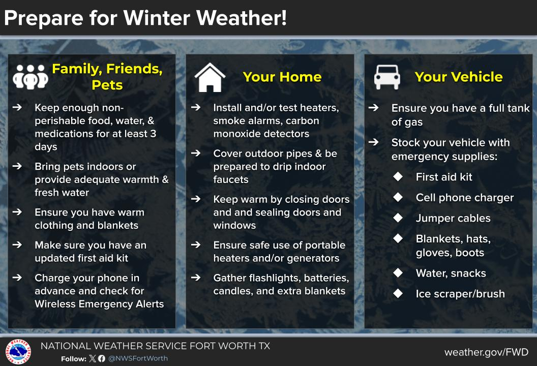
Preparation ahead of time can reduce risk, especially if power outages occur during this Southern Plains winter storm.

Have enough food, water, and medications to last at least three days. Charge phones and backup batteries in advance. If the power goes out, keep blankets, flashlights, and extra batteries within reach.
Bring pets indoors and check on elderly neighbors or family members who may need extra help staying warm. Dress in layers when going outside, and take breaks to warm up. When shoveling snow, take it slow to avoid overexertion.
Generators and Water Pipe Protection
Emergency heat sources should be properly ventilated to prevent carbon monoxide buildup. Generators should always be placed at least 20 feet away from your home and never used indoors or in enclosed spaces.
To help prevent frozen pipes, cover outdoor faucets, and let indoor faucets drip slightly with cabinet doors open to allow warm air to circulate. Knowing where your main water shutoff valve is located can help limit damage if a pipe freezes.
AMS Annual Meeting Travel Considerations
This storm overlaps with travel ahead of the AMS Annual Meeting in Houston, scheduled for January 25–29. Even if conditions in Houston remain manageable, travel routes and connecting flights through the Southern Plains could be affected. Attendees should monitor airline updates and build flexibility into travel plans.
Staying Informed as the Southern Plains Winter Storm Unfolds
As this Southern Plains winter storm continues to develop, forecasts will be refined, and impacts may change. Staying aware of updated information is critical during prolonged winter weather events.
At Wet Dog Weather, our visualization and data tools help teams track evolving winter conditions, compare forecast guidance, and communicate risk clearly. When winter weather threatens travel, safety, and operations, having the right information at the right time matters.

